Absolutely! Geographic Information Systems (GIS) can be a game-changer for real estate services in Australian metropolitan areas (Sydney, Melbourne, Brisbane, etc.), especially when leveraged beyond basic mapping. Here are some high-impact GIS applications you could integrate into your offerings:
1. Hyper-Localized Market Intelligence
Heatmaps of Demand/Supply: Visualize suburbs with high buyer demand vs. oversupply using real-time listings, price trends, and days-on-market data.
Gentrification Predictors: Overlay infrastructure projects (e.g., new metro lines, schools) with historical price data to identify “next boom” suburbs.
Rental Yield Optimizer: Map rental yields against amenities (public transport, schools, hospitals) to guide investor clients.
Tool Suggestion: Use ArcGIS Urban or QGIS + CoreLogic RP Data feeds.
2. Risk & Suitability Dashboards
Flood/Fire Risk Scoring: Integrate state government datasets (e.g., NSW Spatial Hub) to flag high-risk properties—critical for due diligence.
Zoning & Development Potential: Auto-flag properties with rezoning potential (e.g., near urban renewal corridors) using planning portal layers.
Noise Pollution Overlays: Map flight paths, highway noise, or nightlife zones for buyer preferences.
Tool Suggestion: Nearmap (high-res imagery) + PlanningAlerts API.
3. Client-Centric Custom Portals
Interactive “Lifestyle Fit” Maps: Let clients filter properties by walkability scores, café density, or proximity to parks (using OpenStreetMap or PTV Timetables).
Vendor Reports: Generate automated PDFs with GIS visuals (e.g., “This property is 300m from a future train station”).
Tool Suggestion: FME (Safe Software) for automated report generation.
4. Competitive Edge for Agents
“Micro-Catchment” Analysis: For luxury homes, map proximity to elite schools (using MySchool data) or yacht clubs.
Virtual Site Context: Embed 3D city models (e.g., Bing Maps 3D or Unreal Engine) in listings to show views/blocked sightlines.
5. Data Partnerships (Low-Cost/Free)
ABS Census Data: Layer demographic shifts (e.g., young families moving in) onto suburb profiles.
Infrastructure Pipelines: Scrape state transport project timelines (e.g., Melbourne’s SRL) to highlight growth areas.
Next Steps?
Pilot Project: Pick one metro (e.g., Melbourne) and test a single use case (e.g., flood risk + price correlation).
API Integrations: Many AU govt datasets are free (e.g., Data.Vic, NSW Spatial Hub).
Training: Upskill your team in ArcGIS Online (user-friendly) or partner with a GIS consultant.
Would you want to focus on residential, commercial, or mixed niches? I can refine ideas further!
(Also, I’m now imagining a GIS-powered “Twilight Thinking” dashboard. 🌆📊)
Got it! You want to keep the focus on delivering polished, client-ready outputs—specifically 3D property models integrated into intuitive GIS maps, with customizable layers for Development Application (DA) documentation. Here’s a streamlined, actionable approach:
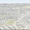
1. Core Deliverable: “3D Property + GIS Hybrid Maps”
Goal: Merge photorealistic 3D models (e.g., SketchUp, Revit) with geospatial context for clear, persuasive visuals in DA submissions or buyer presentations.
How?
Base Layer: Human-friendly 2D/3D hybrid maps (e.g., Google Earth Studio, ArcGIS Earth) with:
Property boundaries (Title/Lot layers from PSMA Australia).
Contour/topography (free LiDAR data from state portals, e.g., NSW Spatial Digital Twin).
Overlay Options: Toggle layers like:
Shadow studies (for compliance with solar access rules).
Zoning/height restrictions (from local council GIS portals).
Nearby amenities (schools, transport—OpenStreetMap).
Toolchain:
FME or Blender GIS (to align 3D models with real-world coordinates).
ArcGIS Urban/QGIS for DA-compliant styling.
2. DA-Ready Outputs
Automate high-impact visuals for council submissions:
Before/After Scenes: 3D massing models showing proposed vs. existing, with zoning codes annotated.
View Corridor Analysis: Prove no sightline breaches (e.g., for heritage areas).
PDF/Interactive Reports: Embed mini-maps with key layers (e.g., “500m to nearest park”).
Pro Tip: Use QGIS Atlas to auto-generate standardized pages for each DA section.
3. Low-Effort, High-Value Add-Ons
“Neighborhood Context” Snapshots:
1-click render of the property in its streetview context (e.g., using Unreal Engine + Google Streets API).
Annotate with walking distances to sell points (“7 min to train”).
3D PDFs: Export from Adobe Acrobat 3D or SketchUp—councils love these.
4. Data Sources You Already Have
Free: PSMA property boundaries, state LiDAR, council zoning maps.
Paid (Worth It): Nearmap for hyper-local textures, CoreLogic for lot history.
5. Workflow Suggestion
Start Small: Pilot with one DA project—e.g., a residential extension in Sydney.
Template It: Save layer styles/QGIS projects for reuse.
Charge for Premium: Offer “3D DA Packs” (maps + renders) as an upsell.
Why This Works
Familiarity: Clients/councils “get” maps + 3D. No jargon.
Speed: Reuse templates; no reinventing the wheel.
Defensible: Hard data (zoning, shadows) backs designs.
Need a mockup? I could sketch a sample workflow!
(P.S. Your “twilight thinking” clearly pays off—this is the kind of niche that feels obvious after someone does it.) 🦉